
GPS data can identify congestion hot spots
Traffic congestion on urban roadways can influence operating costs and cause travel delays.
Portland State University master’s students Nicholas Stoll and Travis Glick will present a paper introducing solutions for locating the sources of congestion at the 2016 annual meeting of the Transportation Research Board.
With their faculty advisor, Miguel Figliozzi, Stoll and Glick looked into using bus GPS data to identify congestion hot spots.
By using high-resolution GPS data to visualize trends in bus behavior and movement, the researchers were able to examine the sources of delay on urban arterials.
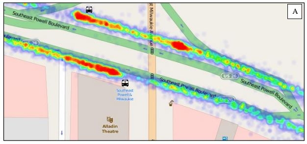
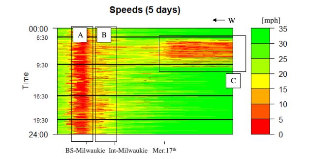 These visualizations, which can be in the form of heat maps or speed plots like the one shown here on the right (an application of numerical method applied to a 2,000 ft segment of SE Powell), can be used by transportation agencies to identify locations where improvements are needed. For example, adding a queue jump lane at a congested intersection can improve flow.
The researchers used fine-grained bus data provided by TriMet to create the visualizations. Buses have been used as probes to estimate travel times before, but with coarser data. Previous studies involving TriMet buses were confined to stop-level data, which provided times for bus arrivals and departures from a stop. This study uses high-resolution data, including bus position and identification, which became available from TriMet in late 2013.
This tool can be used to examine general behavior of buses and select areas that call for further exploration.
From their initial data exploration, the researchers chose four distinct segments for further numerical analysis.
The analysis showed that the visualizations of bus data could be successfully used to discover trends and travel patterns with only a few days’ worth of data.
 Stoll, who earned his B.A. in physics from St. Olaf College in Minnesota, is a graduate research assistant working toward a master of urban and regional planning degree at PSU.
Figliozzi is a professor in civil engineering and director of the Transportation Technology and People (TTP) lab at PSU.
 Glick is a graduate teaching and research assistant in civil and environmental engineering at PSU, who began the master’s program after completing his B.S. in civil engineering at PSU in 2015.
The practice-ready paper, No. 16-6876, is titled “Utilizing High-Resolution Bus GPS Data to Visualize and Identify Congestion Hot Spots in Urban Arterials.” The authors will present the research in a lectern session at 8:00 a.m. in in the Walter E. Washington Convention Center, Room 150A, on Monday, January 11.
- Stoll will present this research Friday, January 22 in a TREC Friday Transportation Seminar at Portland State University.
- Download the full paper
- Read more of our TRB coverage