Transportation can have a significant impact on vulnerable ecologies, especially in rapidly urbanizing regions such as Dallas/Fort Worth. In order for future professionals to balance the needs of sensitive environments with the mobility of people and goods, they must have the proper tools – among other things, a good grounding in regional mapping technologies.
To introduce high school students ...Transportation can have a significant impact on vulnerable ecologies, especially in rapidly urbanizing regions such as Dallas/Fort Worth. In order for future professionals to balance the needs of sensitive environments with the mobility of people and goods, they must have the proper tools – among other things, a good grounding in regional mapping technologies.
To introduce high school students to geographic information systems (GIS) and spatial reasoning skills, researchers at the University of Texas at Arlington (UTA) developed a four-week training workshop in ArcGIS and other emerging regional mapping technologies. The workshop was incorporated into an existing high school course focused on the transportation network and issues related to environmental justice in the communities along the Trinity River.
Led by the research team from UTA's College of Architecture, Planning and Public Affairs (Joowon Im, Assistant Professor of Landscape Architecture, Alan Klein, Director at Institute of Urban Studies, Amruta Sakalker, Graduate Assistant in Planning), they partnered with CityLab High School in the Dallas Independent School District to pilot this workshop. The curriculum, which can be replicated for use by other teachers, introduces students to the connections between transportation planning and design and environmental justice.
Download the curriculum modules or access the full final report via the links below.
TEACHING THROUGH A UNIVERSITY / HIGH SCHOOL PARTNERSHIP
Most often university research is primarily shared in higher academic outlets and journals, limiting its impact on young people in high school – the future students at those universities. Although research and education partnerships are highly beneficial to both universities and high schools, they can be challenging to set up and maintain. This project co-created GIS curriculum with high school teachers, incorporating the four-week workshop into a studio class at CityLab High School.
"The Dallas Fort Worth metroplex is experiencing drastic urbanization due to a population boom which has had a large impact on natural resources like the Trinity River, and led to many neighborhoods lacking access to walkable and safe green spaces. Partnering with a high school allowed us to apply our research in a setting that could directly benefit from the knowledge: the students, the school, and the people living in and around Trinity. This helps build upward mobility and shape the future of the transportation workforce," Im said.
This partnership had the compound benefits of introducing students to important STEAM (Science, Technology, Engineering, Art and Math) skills while also contributing to an improved understanding of the issues faced by communities living in the Trinity River watershed. The project had three stages:
Curriculum development and data collection
A pilot lab workshop with GIS tutorials and a field trip to Trinity River
A Spring 2022 exhibition and feedback
Curriculum Development & Data Collection
The research team worked with faculty at CityLab to develop a GIS curriculum that could be incorporated into an existing studio course at the high school, which focused on the transportation network and issues related to environmental justice for the communities along the Trinity River. Segments of the Trinity River flow across multiple cities in the Dallas/Fort Worth area. The researchers downloaded, cleaned, and simplified data from multiple data sources for the students' use, including shapefiles of DFW cities, neighborhood amenities adjacent to the Trinity River like parks, river access points, trails, bus stops and DART rail stops, highways, and the CDC (Centers for Disease Control and Prevention) vulnerability data for neighborhoods near the river. They used this data to create a base map, which served as a starting point for the students to engage with the GIS interface, observe and interact with all the information made available.
Pilot Lab Workshop with GIS Tutorials and Field Trip
Next, the team tested the curriculum via a four-week pilot workshop, held in September 2021 with a class of 30 students. The workshop included lab instruction in GIS with tutorials that were provided virtually, guest lectures (both virtually or in person) from transportation and environmental planning experts, and site surveys with emerging technologies, such as drone captured observations.
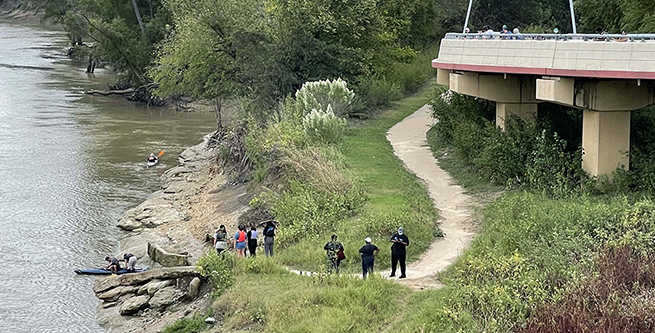
Partnering with Trinity Coalition, an environmental and recreation-based regional nonprofit, the students went on a field trip to Moore Park, a local park adjacent to the Trinity River with a river launch, DART rail station, DART bus stop, and a neighborhood green space. Students had the opportunity to do a short kayak trip with volunteers from Trinity Coalition. The UTA team developed a field trip observational survey, and students compared their observations and analysis in the classroom to site observations. Volunteers from the North Texas Master Naturalists brought environmental educational materials to talk about local wildlife and wetland features. The students also got the opportunity to fly a drone and document environmental resources and trail connections along the river edge.
Exhibition & Feedback
Finally, the students exhibited their work in March and April of 2022, which highlighted the effectiveness of the GIS transportation analysis as a context study for the students’ studio course. The exhibition was arranged by the research team in collaboration with the American Institute of Architects, Dallas chapter and held at their exhibition space in downtown Dallas. Students shared their achievements and work with the partners involved in the project, their teachers, and parents.
While composing the GIS analysis, the students were encouraged to engage in complex local urban issues, understand the needs of the communities, and explore design solutions to propose creative and practical improvement strategies. The curriculum demonstrates the interdisciplinary relationship between transportation planning, sustainability, and architecture to students with future trajectories in transportation and related fields. It also enabled students to apply new software skills to real-world cases around them.
WHAT CAN EDUCATORS TAKE FROM THIS?
Teachers and students provided feedback in an online survey, and one student shared that they appreciated becoming proficient with the basics of the GIS software. Another student said that the GIS workshop was well-paced and informative. The teachers were satisfied overall, and most of the comments indicated that students enjoyed learning new skills.
The outcomes of this project include a set of curriculum modules with supplementary materials which are ready for use in an online format, or can be adapted to an in-person classroom setting. The workshop is a multifaceted experience that includes a field trip and guest lectures, and the final report offers ideas and resources for educators seeking to replicate this curriculum. Educators looking to reproduce this workshop in their schools will find a wealth of tools to help introduce high school students to the transportation field and its multiple overlapping disciplines.See More