
Watch video
The video begins at 1:18.
View slides
Summary: Dr. Lovell will talk about three projects funded by NASA and the FAA, addressing congestion in the National Airspace System. Dr. Lovell's team developed diffusion-based queuing models of individual airports that could support better building blocks for network-wide congestion models. The advantage of the new models is their flexibility with respect to input distributions. In a study for the FAA, Dr. Lovell's team developed day-of-operations collaboration "languages" suitable for the FAA and individual carriers in order to collectively manage expected airspace disruptions. Finally, he will discuss a study on predictability in the airspace, with a focus on scheduled block times.
Dr. Lovell is an Associate Professor with joint appointments in the Department of Civil and Environmental Engineering and the Institute for Systems Research. He is a member of the faculty of the Applied Mathematics, Statistics, and Scientific Computation Program. He is director of the University of Maryland chapter of Engineers Without Borders - USA, and serves that organization on its board and as a leader of one of its Technical Advisory Councils. Dr. Lovell received his B.A. in Mathematics from Portland State University in 1990, and M.S. and Ph.D....
Read moreView presentation slides
View example slides
The LCN+ Project Management team are responsible for improving conditions for cycling on a 900-kilometre network of London’s key commuter roads, in line with the Mayor of London’s Cycling Action Plan.
With the initial target of achieving a 200% increase in the number of cyclists in London already surpassed, the project aims to build on this by continuing to advise the 33 London boroughs on how to improve cycling infrastructure on their roads. By effectively liasing with major stakeholders such as local cycling groups, Borough Cycling Officers and Transport for London, the project can ensure that all will have agreed on the solutions reached.
Steve Cardno: Steve is the Project Manager for the London Cycle Network Plus (LCN+) project, with responsibility for the overall project management of this London wide cycling project. The LCN+ project aims to deliver 900km of high quality strategic cycle routes across London by the end of 2009/10. The project is funded by Transport for London (TfL), project managed by Camden Consultancy Services and delivered in partnership with TfL, CCS, the 33 London Boroughs and cycle user...
Read moreThe video begins at 1:37.
View slides
Summary: Signalized intersections often rely on vehicle detection to determine when to give a green light. The 2009 Manual of Uniform Traffic Control Devices (MUTCD) includes an on-pavement marking and curbside sign that public agencies can use to indicate where cyclists should position themselves while waiting at an intersection. This presentation reviews the effectiveness of current markings, signs, and other methods used to help cyclists properly position themselves over detection.
Stefan Bussey is an undergraduate civil engineering student at Portland State University. He is interested in exploring how road users’ interactions with each other and the built environment affect the efficiency and safety of road networks. He currently works as a civil design intern at Harper Houf Peterson Righellis Inc.
The video begins at 0:13.
Classic highway traffic flow theory can explain the evolution of signals and waves once they form. Given sufficient boundary conditions the theory captures the evolution of the traffic state over space and time. But one rarely finds such ideal boundaries on real highways. Often disturbances arise within a region that classic theory would tell us should be homogeneous. These disturbances often grow and give rise to unstable traffic upstream, e.g., resulting in stop-and-go conditions during congestion with an increased frequency of accidents. This talk will examine one potential source of these disturbances, namely the fact that after a lane change maneuver drivers accommodate an entering vehicle quicker than a departing vehicle (mandatory accommodation versus discretionary accommodation). After illustrating this imbalance on two facilities, the talk will explain how it can give rise to lasting disturbances.
Dr. Coifman is an associate professor at the Ohio State University with a joint appointment in the department of Civil and Environmental Engineering and Geodetic Science and the Department of Electrical Engineering. His research emphasizes extracting more information about traffic flow both from conventional vehicle detectors and emerging sensor technologies. His work has been recognized by the ITS America Award for The Best ITS Research and an NSF CAREER award. Dr. Coifman...
Read more
Watch video
View slides
In this seminar, Dr. Porter will explore the interactions of geometric design decisions, speed, and safety. A performance-based approach to this topic will be considered given the availability of several key documents, including the Highway Safety Manual and TRB's Modeling Operating Speed: Synthesis Report as well as a significant body of published research. A historical look at the design speed concept will show that while the design speed definition has changed on more than one occasion, the same basic but flawed philosophy that relates design speed to a “safe speed” is still reflected in supplemental guidance related to design speed selection in current design policy. A conservative approach to establishing design criteria, currently used to address the range of driver, vehicle, and roadway conditions and capabilities that a designer must consider, will be demonstrated. Resulting operating speeds will be shown to be higher than design speeds for design speeds of approximately 55 mph or less. This outcome may be considered undesirable...
Read moreThe video begins at 2:34.
View slides
Other presentation materials: Handout (PDF)
Summary: The recent City Club report on bicycling provided an opportunity to collect and analyze a number of data sets including the new Hawthorne Bridge data. One question is where Portland bicycling on the logistic curve -- a common tool for judging the maturity of a developing product or activity. Logistic curves are used for marketing, for epidemiology, and even for visits to Indian owned casinos. The preliminary evidence is that we are reaching the horizontal area of the curve. Additional evidence Our further research into future policies indicates a shift to bicycle boulevards in order to attract more risk averse riders.
Bio: Robert McCullough is an energy economist (and an adjunct at PSU) who has written, talked, and testified on energy issues across the U.S. and Canada. He was instrumental in the identification and prosecution of Enron's energy traders. He also works with aboriginal groups in Quebec and Oregon, activists in California and Ohio, as well as many others. His most recent project is the economic review of the WNP-2 nuclear station for Physicians for Social...
Read more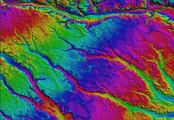
Watch video
View slides
Light detection and ranging (LIDAR) technology is reshaping the civil engineering profession and offers many unique advantages. National efforts such as the 3D Elevation Plan (3DEP) are helping increase the availability of LIDAR data. LIDAR is one of the crucial technologies that is transitioning the world of civil and construction engineering from 2D paper-based design to 3D digital design. The high spatial resolution and accuracy capabilities of LIDAR have led to increased efficiencies, improved analyses, and more informed decision making.
A further advantage of this dataset is that multiple people can use the same dataset for a variety of purposes across multiple disciplines. The visual nature of the dataset also is more intuitive than traditional data acquisition and analysis techniques. This presentation will provide a brief background of LIDAR , its capabilities, limitations and platforms, and discuss its current and future role in civil engineering. Examples of a wide range of transportation, geotechnical, coastal, and structural engineering, science, and planning applications will be presented including development of mobile LIDAR guidelines for...
Read moreThe video begins at 3:23.
Douglas Bish, Traffic Engineering Services Unit Manager with ODOT, will discuss the Jurisdictionally Blind Safety Program. This program is a safety program designed to address safety needs on all public roads in Oregon. The aim of the program is to foster collaboration between local road jurisdictions, to increase increase awareness of safety on all roads, promote best practices for infrastructure safety, compliment behavioral safety efforts and focus limited resources to reduce fatal and serious injury crashes in the state of Oregon. This seminar will introduce some of the details of the program.