
Economic and Development Benefits of Fixed Route Transit through Denser Housing: A National Assessment
Building upon seven years of research, NITC investigators used economic analysis to determine development outcomes and land use planning implications of different fixed route transit systems (FRT). They have created, analyzed, and shared a nationwide data repository that explores links between transit station proximity and real estate rents, jobs, people, and housing. Earlier research revealed important differences in development outcomes of FRT’s during the 2000's, but the significantly expanded data repository offers a more representative look at development outcomes after the Great Recession and with 22 new FRT systems added.
The main takeaway from this expanded analysis? Only 5% of all residents in the U.S., compared to 48% of all jobs, are within a half-mile of FRT stations. Far more jobs exist near transit stations than homes for those workers, and filling in the “missing middle” of housing types (e.g., townhouses, single-family attached units) would put density and affordability within greater reach of many cities.
Led by University of Arizona researcher Arthur C. Nelson, this study was proceeded by his three earlier NITC projects, with a final project forthcoming.:
- Do TODs Make a Difference?
- National Study of BRT Development Outcomes
- Do TODs Make A Difference? Phase 2
- (Summer 2020) LRT/BRT/SCT/CRT Development Outcomes FINAL PHASE : This research will disaggregate data used to assess outcomes based on types or clusters of stations by mode.
WHAT IS FIXED ROUTE TRANSIT?
Up until the early 1980’s, commuter rail and heavy rail transit were the mainstays of FRT systems in the U.S. – serving older, larger cities in the Northeast and the Great Lakes. Fast forward to the early 21st century and we see that most metropolitan areas of more than one million people, and many smaller ones, now operate light rail transit (LRT), streetcar transit (SCT), and bus rapid transit (BRT) in addition to commuter rail transit (CRT) systems. Learn more in our 2014 webinar on LRT and BRT and CRT and SCT ... Oh My!. These systems primarily exist to move people: perhaps mostly to downtown areas, but also to suburban centers, medical centers, educational institutions, sporting and recreation venues and other destinations.
SECONDARY IMPACTS ON DEVELOPMENT, CONGESTION, AND JOB ACCESSIBILITY
Policymakers and planners often envision other objectives to justify the cost of an FRT system such as expanding economic development, making jobs more accessible to lower-income workers and households, reducing congestion and its collateral outcomes such as air pollution, and improving the balance between where people work and live.
Exploring whether FRT systems actually achieve these outcomes is the purpose of this research. The researchers explored ways in which FRT systems, and especially transit stations, make a difference in these areas. The central research question is: Are there differences in development outcomes over time with respect to FRT station proximity, and do these differences vary by type of FRT system?
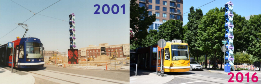
The Portland Streetcar has grown alongside new residential development since its inauguration in 2001:
KEY FINDINGS OF EXPANDED NATIONWIDE DATA
This report expands the number of FRT systems used in analysis from a total of 30 systems to a new total of 52 systems: 17 LRT, 14 BRT, 9 SCT, and 12 CRT systems in 35 metro areas across the United States. It also expands the period of analysis to 2015 for jobs-related data, 2016 for census data, and 2018 for CoStar commercial rent data. The expanded and updated data repository allows for more comprehensive assessment of their outcomes.
Findings reveal that, with greater proximity to FRT systems:
- Market rents increase,
- Regional job share increases,
- Regional share of population and housing increases, and
- Regional share of driving alone and carpooling is reduced.
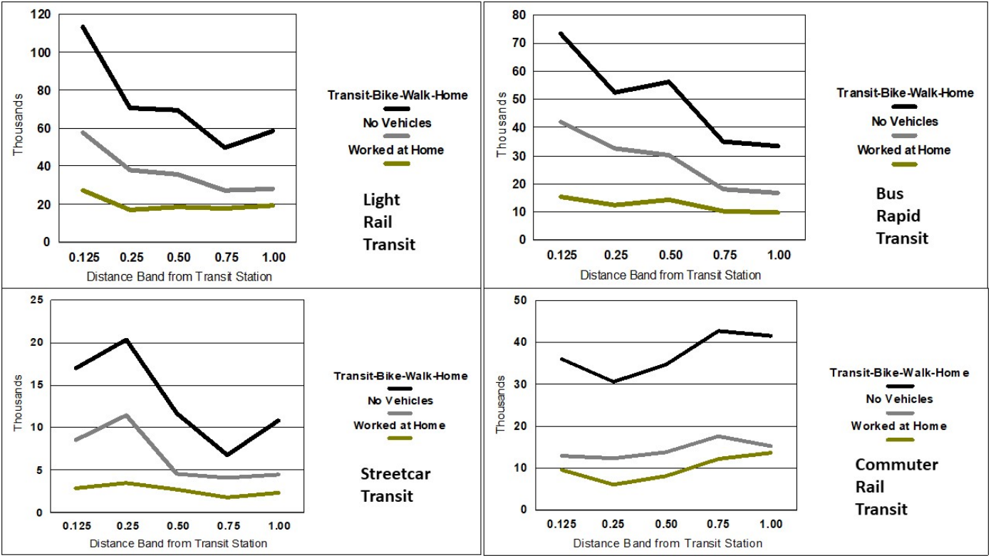
Share of Transit Regional Change in Selected Community Mode Choice, Households without Vehicles, and Workers Working at Home, by Distance Band from LRT, BRT, SCT and CRT Stations, 2010-2016:
TRANSIT AND LAND USE PLANNING IMPLICATIONS
Analyzing these data findings and connecting them to broader implications for planners and policy makers in transit-oriented development (TOD), the researchers found that:
In most cities, far more jobs exist near stations than homes for those workers. Improving this balance with an increase of housing can reduce congestion, improve accessibility and provide greater land use variety near transit stations.
Housing location is relatively more flexible for most workers than employment location, and therefore a focus on housing in an area that is appropriate to a nearby employment sector or wage level may be more effective than providing jobs near housing of a given sector or wage level.
Transportation is also of high importance, and policies should aim to provide greater local accessibility through built environments that help circulate more people without automobile use.
Local-scale wage-housing cost balance is important to efforts to improve both housing and transportation efficiency and equity. Filling in the “missing middle” of housing types (e.g., townhouses, single-family attached units) would put density and affordability in greater reach for many cities.
Of final note, an important statistic indicates where the “low-hanging fruit” exists: only 5% of all residents, compared to 48% of all jobs in the U.S., are within a half-mile of FRT stations. Significant opportunity exists within two miles of transit stations to increase accessibility and jobs-housing balance, while supplying the shifting preference for TOD residence and transit-based commutes.
Planners and policymakers will find a wealth of data to inform these decisions in the report Updating and Expanding LRT/BRT/SCT/CRT Data and Analysis (PDF), and researchers can use the datasets generated by this project to further investigate the interrelationships between jobs, housing, and transit.
This research was funded by the National Institute for Transportation and Communities, with additional support from the City of Tucson, Regional Transportation Council of Southern Nevada, Mid-America Regional Council, Wasatch Front Regional Council, Metro, and the University of Arizona.
RELATED RESEARCH
To learn more about this and other NITC research, sign up for our monthly research newsletter.
- Impacts of Bus Rapid Transit (BRT) on Surrounding Residential Property Values
- Understanding Economic and Business Impacts of Street Improvements for Bicycle and Pedestrian Mobility - A Multi-City Multi-Approach Exploration
- Do TODs Make a Difference?
The National Institute for Transportation and Communities (NITC) is one of seven U.S. Department of Transportation national university transportation centers. NITC is a program of the Transportation Research and Education Center (TREC) at Portland State University. This PSU-led research partnership also includes the Oregon Institute of Technology, University of Arizona, University of Oregon, University of Texas at Arlington and University of Utah. We pursue our theme — improving mobility of people and goods to build strong communities — through research, education and technology transfer.